|
Reported Crop Circles for the State
of Wisconsin -
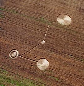
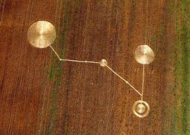
Clyman, Dodge County (August 8, 2003)
This formation comprised of 7 circles and associated pathways extended close to 300’ over a hill. Some parts for the formation could not be seen standing in other parts. The largest circle (the only part of the formation visible from the road) was 78’ in diameter.

First spotted by local neighbors around the 4th of July, but not reported. Investigators spotted it on August 9th. No tracks lead into the formation.

“Blown nodes” (expulsion cavities) were found, and the formation was authenticated using the L-NEAT protocol.
The farmer harvested the formation the day it was surveyed.
Crop
type: grass
Source and Photos: ICCRA
|
|
City
/ County / Date:
- Woodman, Grant County
(July, 1980)
- Blanchardville, Lafayette County (September 5, 1981)
- Foster's Tree Farm [city unknown], (September, 1984)
- Dundee, Monroe County
(May, 1985)
- Mukwonago, Waukesha County (February, 1987)
- Kenosha, Kenosha County
(May 2, 1993)
- Milwaukee, Milwaukee County (August 14, 1994)
- Long Lake, Florence County
(July 5, 1995)
- Wausau, Marathon County (August 13, 1997)
- Wausau, Marathon County (August 16, 1997)
- Port Washington, Ozaukee County (July 10, 1998)
- [Unknown], (1998)
- Verona, Dane County
(October 3, 1999)
- Mayville / Kekoskee, Dodge County (July 4, 2003)
- Theresa, Dodge County
(July 11, 2003)
- Mayville, Dodge County
(July, 2003)
- Mayville, Dodge County
(August 8, 2003)
- Clyman, Dodge County
(August 8, 2003)
- Mayville, Dodge County
(August 9, 2003)
- Tilden / Chippewa Falls, Chippewa County (July 19, 2004)
- Wausau, Marathon County (August 27, 2004)
- Trevor, Kenosha County
(June 21, 2005)
- Mayville, Dodge County
(July 6, 2005)
|